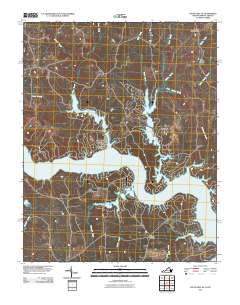
2010 Map of South Hill SE
USGS Topo · Published 2010About this map
The Roanoke River bisects this Virginia landscape, where the rising waters of Lake Gaston have created a complex shoreline of flooded inlets and finger-like coves. The 2010 survey shows a transition between traditional crossroads and modern waterside development, with Joyceville situated near the branching arms of Miles Creek and Poplar Creek. This pattern of development suggests the significant impact of twentieth-century hydroelectric and recreational water management on the historical topography of Mecklenburg County.
Find a feature on this map
17 named features on this map. Tap any name to fly to it.
Don’t see what you’re looking for? This feature index may not catch every label — zoom into the map to look around manually.
Map Details
Editions of this 2010 South Hill SE Map
This is the sole edition of this map. No revisions or reprints were ever made.
Other maps of this area

1919 · White Plains
USGS Topo · 1:48,000

1920 · White Plains
USGS Topo · 1:62,500

1953 · Norfolk
USGS Topo · 1:250,000

1953 · Greensboro
USGS Topo · 1:250,000

1954 · Greensboro
USGS Topo · 1:250,000

1962 · Greensboro
USGS Topo · 1:250,000

1963 · Gasburg
USGS Topo · 1:24,000

1963 · White Plains
USGS Topo · 1:24,000

1966 · Greensboro
USGS Topo · 1:250,000

1968 · South Hill SE
USGS Topo · 1:24,000