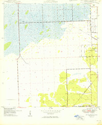
1949 Map of South Miami NW
USGS Topo · Published 1949About this map
The US Naval Air Station and the settlement of Richmond anchor the southern edge of this landscape, reflecting the military and institutional presence west of Miami in the late 1940s. The terrain transitions from developing suburban grids into the expansive marshes of the Everglades, defined by a distinct network of straight-line roads and canals. Institutional landmarks like the Dade County Home and Hospital and the original Tamiami Airport sit on the fringe of the wetlands, while the WROD Radio Sta and the Seaboard Air Line railroad trace the corridor of early communication and transport.
Find a feature on this map
18 named features on this map. Tap any name to fly to it.
Don’t see what you’re looking for? This feature index may not catch every label — zoom into the map to look around manually.
Map Details
Editions of this 1949 South Miami NW Map
2 editions found
Other maps of this area

1949 · South Miami NW
USGS Topo · 1:24,000

1949 · Goulds
USGS Topo · 1:24,000

1949 · Perrine
USGS Topo · 1:24,000

1950 · Hialeah
USGS Topo · 1:24,000

1950 · South Miami
USGS Topo · 1:24,000

1955 · South Miami NW
USGS Topo · 1:24,000

1956 · Goulds
USGS Topo · 1:24,000

1956 · Perrine
USGS Topo · 1:24,000

1956 · South Miami
USGS Topo · 1:24,000

1956 · Grossman Hammock
USGS Topo · 1:24,000