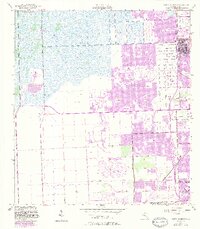
1955 Map of South Miami NW
USGS Topo · Published 1983About this map
Tamiami Airport and the sprawling Naval Reservation dominate this western Dade County landscape during a period of rapid suburban transition. This 1955 survey, updated through the early 1980s, captures the outward push of Miami's residential developments such as Westwood Lake and Richmond Heights into former agricultural and wetland areas. The infrastructure of the era is clearly defined by the expansion of Florida's Turnpike Extension and the South Dade Expressway, which slice through the traditional grid of roads like Bird Drive and Krome Avenue. Local institutions are well-represented, including the University of Miami (South Campus) and the Paradise Memorial Cem. The map illustrates the shift from a rail-dependent economy, evidenced by the Seaboard Coast Line, to a landscape increasingly defined by major highway corridors and large-scale land use projects like the various Golf Course developments and the drainage network of Snapper Creek.
Find a feature on this map
22 named features on this map. Tap any name to fly to it.
Don’t see what you’re looking for? This feature index may not catch every label — zoom into the map to look around manually.
Map Details
Editions of this 1955 South Miami NW Map
4 editions found
Other maps of this area

1949 · South Miami NW
USGS Topo · 1:24,000

1949 · Goulds
USGS Topo · 1:24,000

1949 · Perrine
USGS Topo · 1:24,000

1950 · Hialeah
USGS Topo · 1:24,000

1950 · South Miami
USGS Topo · 1:24,000

1955 · South Miami NW
USGS Topo · 1:24,000

1956 · Goulds
USGS Topo · 1:24,000

1956 · Perrine
USGS Topo · 1:24,000

1956 · South Miami
USGS Topo · 1:24,000

1956 · Grossman Hammock
USGS Topo · 1:24,000