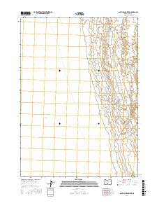
2017 Map of South of Ana River
USGS Topo · Published 2017About this map
Summer Lake dominates the western half of this landscape in Lake County, defining the hydrology and land use patterns of the Great Basin. This 2017 survey illustrates the expansive, shallow terminal lakebed, an area where the transition between water and alkali flats is shaped by seasonal fluctuations. The eastern portion of the map is defined by the rigid grid of the Public Land Survey System, specifically within the boundaries of t31s r17e, t31s r18e, t32s r17e, and t32s r18e. This area represents a classic example of high-desert geography where modern mapping data from the National Hydrography Dataset and the National Elevation Dataset provide a precise view of the lake's shoreline and the surrounding arid basin.
Find a feature on this map
5 named features on this map. Tap any name to fly to it.
Don’t see what you’re looking for? This feature index may not catch every label — zoom into the map to look around manually.
Map Details
Editions of this 2017 South of Ana River Map
This is the sole edition of this map. No revisions or reprints were ever made.
Other maps of this area

1955 · Klamath Falls
USGS Topo · 1:250,000

1958 · Klamath Falls
USGS Topo · 1:250,000

1966 · Summer Lake
USGS Topo · 1:24,000

1966 · Slide Mtn
USGS Topo · 1:24,000

1966 · Harvey Creek
USGS Topo · 1:24,000

1966 · Fremont Point
USGS Topo · 1:24,000

1966 · Paisley
USGS Topo · 1:24,000

1974 · Lake Abert
USGS Topo · 1:100,000
1986 · Ana River
USGS Topo · 1:24,000
1986 · Loco Lake
USGS Topo · 1:24,000