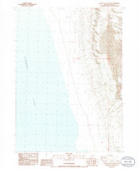
1986 Map of South of Ana River
USGS Topo · Published 1986About this map
Summer Lake dominates this mid-1980s landscape, occupying a vast portion of the northwestern terrain. The map details the transition from the expansive water body to the complex topography of the high desert along the eastern shore. Grounded in a 1981 field check, the survey documents the intricate network of township and range lines, such as t31s t32s and r17e r18e, which provide the legal framework for this remote corner of Lake County. This provisional edition is particularly valuable for its recording of unimproved roads and trails that traverse the rising slopes east of the lake, offering a precise view of the rural infrastructure before modern developments. The interplay between the flat basin of the lake and the neighboring ridges is rendered with a five-foot contour interval, providing exceptional clarity for those studying the hydrology and land use of the region during this era.
Find a feature on this map
3 named features on this map. Tap any name to fly to it.
Don’t see what you’re looking for? This feature index may not catch every label — zoom into the map to look around manually.
Map Details
Editions of this 1986 South of Ana River Map
This is the sole edition of this map. No revisions or reprints were ever made.
Other maps of this area

1955 · Klamath Falls
USGS Topo · 1:250,000

1958 · Klamath Falls
USGS Topo · 1:250,000

1966 · Summer Lake
USGS Topo · 1:24,000

1966 · Slide Mtn
USGS Topo · 1:24,000

1966 · Harvey Creek
USGS Topo · 1:24,000

1966 · Fremont Point
USGS Topo · 1:24,000

1966 · Paisley
USGS Topo · 1:24,000

1974 · Lake Abert
USGS Topo · 1:100,000
1986 · Ana River
USGS Topo · 1:24,000
1986 · Loco Lake
USGS Topo · 1:24,000