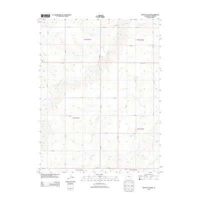
2013 Map of South of Flagler
USGS Topo · Published 2013About this map
The S Fork Republican River cuts through the high plains of Kit Carson County, anchoring a landscape defined by an orderly grid of section lines and gravel paths. This 2013 survey documents a predominantly agricultural region where the hydrology of Sand Cr and Spring Cr dictates the local topography. The map illustrates the strict Public Land Survey System organization of eastern Colorado, with the intersection of Co Road 5 and numerous east-west routes like Co Road L and Co Road G providing the primary framework for movement. While no major towns are featured, the placement of these county roads and the behavior of the intermittent creek beds provide essential data for understanding modern land use and drainage patterns in this portion of the Republican River basin.
Find a feature on this map
23 named features on this map. Tap any name to fly to it.
Don’t see what you’re looking for? This feature index may not catch every label — zoom into the map to look around manually.
Map Details
Editions of this 2013 South of Flagler Map
This is the sole edition of this map. No revisions or reprints were ever made.
Other maps of this area

1954 · Limon
USGS Topo · 1:250,000

1957 · Limon
USGS Topo · 1:250,000

1958 · Limon
USGS Topo · 1:250,000

1978 · Hugo 4 NW
USGS Topo · 1:24,000

1979 · Hugo 4 NE
USGS Topo · 1:24,000

1979 · Flagler SW
USGS Topo · 1:24,000

1979 · Flagler
USGS Topo · 1:24,000
1979 · Hugo 4 SE
USGS Topo · 1:24,000
1979 · Hugo 4 NW
USGS Topo · 1:24,000
1979 · Stratton 3 SW
USGS Topo · 1:24,000