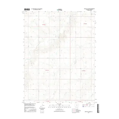
2016 Map of South of Flagler
USGS Topo · Published 2016About this map
The South Fork Republican River cuts a prominent diagonal across this section of the High Plains, carving out the primary drainage system for the surrounding Kit Carson County tablelands. In this 2016 survey, the land remains defined by the rigid grid of the Public Land Survey System, with county roads such as Co Rd 5 and Co Rd 3 following section lines through the township blocks of T9S, T10S, and T11S. Water is the primary sculptor of the landscape here, with the Sand Cr and Spring Cr systems creating a network of draws and intermittent drainages that interrupt the otherwise uniform agricultural and grazing blocks. This map provides a clear view of the rural infrastructure in eastern Colorado, where transportation is dictated by the intersection of natural river valleys and the man-made section road system, including routes like Co Rd N and Co Rd L.
Find a feature on this map
23 named features on this map. Tap any name to fly to it.
Don’t see what you’re looking for? This feature index may not catch every label — zoom into the map to look around manually.
Map Details
Editions of this 2016 South of Flagler Map
This is the sole edition of this map. No revisions or reprints were ever made.
Other maps of this area

1954 · Limon
USGS Topo · 1:250,000

1957 · Limon
USGS Topo · 1:250,000

1958 · Limon
USGS Topo · 1:250,000

1978 · Hugo 4 NW
USGS Topo · 1:24,000

1979 · Hugo 4 NE
USGS Topo · 1:24,000

1979 · Flagler SW
USGS Topo · 1:24,000

1979 · Flagler
USGS Topo · 1:24,000
1979 · Hugo 4 SE
USGS Topo · 1:24,000
1979 · Hugo 4 NW
USGS Topo · 1:24,000
1979 · Stratton 3 SW
USGS Topo · 1:24,000