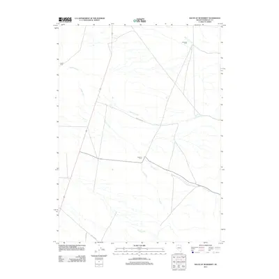
2011 Map of South of McDermitt
USGS Topo · Published 2011About this map
McConnell Ranch and Hoppin Ranch anchor this landscape in northern Humboldt County, where the high desert terrain is defined by a network of seasonal watercourses. The drainage patterns of Canyon Creek and Threemile Creek illustrate the hydrologic character of the Great Basin, where water is the primary factor in settlement patterns. Local transportation relies on a mix of established routes like Old Hwy 95 and rural access points such as Indian Creek Rd and Flat Creek Rd. Remote outposts like Anderson Ranch are situated near the confluence of Pole Creek and Canyon Creek, marking the sparse human presence in this region. This survey captures the relationship between these family-named landmarks and the persistent stream beds like Spring Creek and Eightmile Creek that dictate the location of ranching operations.
Find a feature on this map
11 named features on this map. Tap any name to fly to it.
Don’t see what you’re looking for? This feature index may not catch every label — zoom into the map to look around manually.
Map Details
Editions of this 2011 South of McDermitt Map
This is the sole edition of this map. No revisions or reprints were ever made.
Other maps of this area

1882 · Paradise
USGS Topo · 1:250,000

1893 · Paradise
USGS Topo · 1:250,000

1955 · McDermitt
USGS Topo · 1:250,000

1959 · McDermitt
USGS Topo · 1:250,000

1959 · Orovada
USGS Topo · 1:62,500

1959 · McDermitt
USGS Topo · 1:62,500

1959 · Hinkey Summit
USGS Topo · 1:62,500

1959 · Jordan Meadow
USGS Topo · 1:62,500

1985 · Quinn River Valley
USGS Topo · 1:100,000
1991 · Hoppin Peaks
USGS Topo · 1:24,000