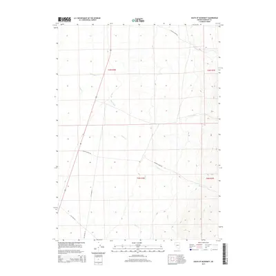
2015 Map of South of McDermitt
USGS Topo · Published 2015About this map
Old Highway 95 serves as the primary north-south artery through this arid stretch of Humboldt County, tracing the historical corridor south of the Oregon border. The landscape is defined by the drainage patterns of several seasonal streams, including the eastward-flowing Threemile Cr and Eightmile Cr. To the south, the terrain becomes increasingly complex as Canyon Cr and its tributaries, such as Pole Cr, cut through the basin.
Find a feature on this map
13 named features on this map. Tap any name to fly to it.
Don’t see what you’re looking for? This feature index may not catch every label — zoom into the map to look around manually.
Map Details
Editions of this 2015 South of McDermitt Map
This is the sole edition of this map. No revisions or reprints were ever made.
Other maps of this area

1882 · Paradise
USGS Topo · 1:250,000

1893 · Paradise
USGS Topo · 1:250,000

1955 · McDermitt
USGS Topo · 1:250,000

1959 · McDermitt
USGS Topo · 1:250,000

1959 · Orovada
USGS Topo · 1:62,500

1959 · McDermitt
USGS Topo · 1:62,500

1959 · Hinkey Summit
USGS Topo · 1:62,500

1959 · Jordan Meadow
USGS Topo · 1:62,500

1985 · Quinn River Valley
USGS Topo · 1:100,000
1991 · Hoppin Peaks
USGS Topo · 1:24,000