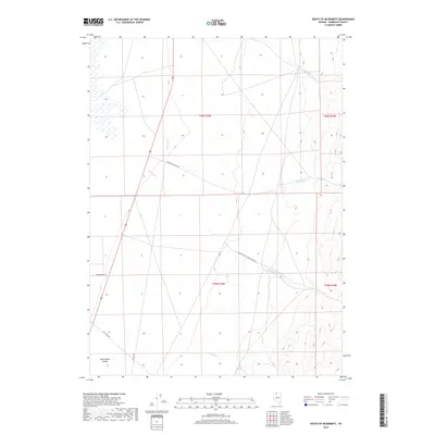
2018 Map of South of McDermitt
USGS Topo · Published 2018About this map
Quinn River Valley defines the lower reaches of this high-desert landscape in Humboldt County, where drainage systems from the surrounding mountains converge onto the valley floor. The map illustrates a complex network of seasonal watercourses including Threemile Cr, Eightmile Cr, and Canyon Cr, which descend toward the basin. The transportation infrastructure is anchored by Old Hwy 95, running parallel to the newer highway corridor, while ranching and access roads like Buckskin Canyon Rd and Indian Creek-Canyon Creek Rd push into the more topographically varied eastern terrain. The presence of Brinkerhoff Ln and Flat Creek Rd suggests the historical importance of specific homesteads or grazing access points in this corner of northern Nevada, providing a clear record of land use and water management in the late 2010s.
Find a feature on this map
15 named features on this map. Tap any name to fly to it.
Don’t see what you’re looking for? This feature index may not catch every label — zoom into the map to look around manually.
Map Details
Editions of this 2018 South of McDermitt Map
This is the sole edition of this map. No revisions or reprints were ever made.
Other maps of this area

1882 · Paradise
USGS Topo · 1:250,000

1893 · Paradise
USGS Topo · 1:250,000

1955 · McDermitt
USGS Topo · 1:250,000

1959 · McDermitt
USGS Topo · 1:250,000

1959 · Orovada
USGS Topo · 1:62,500

1959 · McDermitt
USGS Topo · 1:62,500

1959 · Hinkey Summit
USGS Topo · 1:62,500

1959 · Jordan Meadow
USGS Topo · 1:62,500

1985 · Quinn River Valley
USGS Topo · 1:100,000
1991 · Hoppin Peaks
USGS Topo · 1:24,000