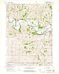
1962 Map of South Wayne
USGS Topo · Published 1964About this map
South Wayne serves as the primary hub along the winding Pecatonica River in this early 1960s survey of Lafayette County. The landscape is defined by the sharp bends of the river and the diagonal path of the Chicago Milwaukee St Paul and Pacific railroad, which historically dictated the growth and transit patterns of the region. This era reflects a high density of rural institutions, particularly one-room schools such as Mud Hollow Sch, West Wayne Sch, and Wayne Center Sch, most of which were situated at crossroads to serve the surrounding farmsteads.
Find a feature on this map
33 named features on this map. Tap any name to fly to it.
Don’t see what you’re looking for? This feature index may not catch every label — zoom into the map to look around manually.
Map Details
Editions of this 1962 South Wayne Map
This is the sole edition of this map. No revisions or reprints were ever made.
Other maps of this area

1902 · Mineral Point
USGS Topo · 1:125,000

1911 · Elizabeth
USGS Topo · 1:62,500

1923 · South Wayne
USGS Topo · 1:62,500

1936 · Elizabeth
USGS Topo · 1:62,500

1937 · Lena
USGS Topo · 1:48,000

1942 · Lena
USGS Topo · 1:62,500

1943 · Lena
USGS Topo · 1:62,500

1954 · Rockford
USGS Topo · 1:250,000

1955 · Rockford
USGS Topo · 1:250,000

1958 · Rockford
USGS Topo · 1:250,000