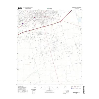
2016 Map of Southeast Midland
USGS Topo · Published 2016About this map
Midland expanded significantly into the Permian Basin's arid landscape by 2016, a growth pattern clearly etched into this topographic record. The urban grid of the city's southeast corner transitions sharply into a vast network of section roads, including W Co Rd 124 and W Co Rd 140, which facilitate movement through the oil-rich West Texas plains. Key transportation arteries like the Bankhead Hwy and W Industrial Ave anchor the northern industrial and commercial sectors, reflecting the city's long-standing role as a regional energy hub. This survey illustrates the contrast between dense development and the natural drainage systems of Midland Draw and Monahans Draw, which snake through the southeastern territory. These ephemeral watercourses remain defining geographic markers in a landscape otherwise dominated by a rigid, man-made grid of county roads and petroleum infrastructure.
Find a feature on this map
252 named features on this map. Tap any name to fly to it.
Don’t see what you’re looking for? This feature index may not catch every label — zoom into the map to look around manually.
Map Details
Editions of this 2016 Southeast Midland Map
This is the sole edition of this map. No revisions or reprints were ever made.
Other maps of this area

1954 · Hobbs
USGS Topo · 1:250,000

1954 · Pecos
USGS Topo · 1:250,000

1954 · Big Spring
USGS Topo · 1:250,000

1954 · San Angelo
USGS Topo · 1:250,000

1957 · Pecos
USGS Topo · 1:250,000

1958 · San Angelo
USGS Topo · 1:250,000

1958 · Big Spring
USGS Topo · 1:250,000

1958 · Hobbs
USGS Topo · 1:250,000

1964 · Bryant Ranch
USGS Topo · 1:24,000

1964 · Parks
USGS Topo · 1:24,000