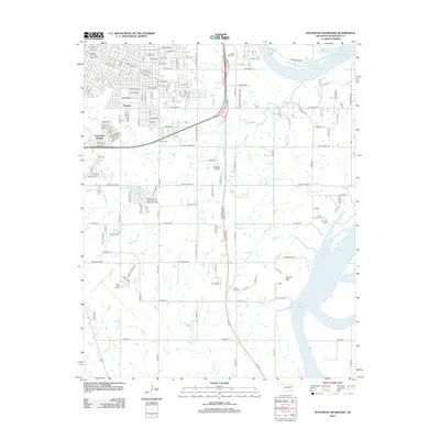
2012 Map of Southeast Muskogee
USGS Topo · Published 2012About this map
Webbers Falls Reservoir dominates the eastern boundary of this Oklahoma landscape, where the Arkansas River floodplain gives way to the rising elevation of Brushy Mtn. The transition from the urban grid of Grandview Heights and Shopton to the rural south is marked by a network of sectional roads and the expansive Muskogee Industrial Park. Aviation history is well-represented by both Davis Field Airport and the smaller Bluebird Airport, reflecting the region's importance as a transportation hub. Local genealogy is anchored by several long-standing burial sites, including Frozen Rock Cem to the north and Brushy Mtn Cem near the mountain's base. Creeks like Coody Cr and Salt Cr weave through the terrain, defining the drainage patterns that shaped early settlement and later agricultural developments in this part of Muskogee County.
Find a feature on this map
70 named features on this map. Tap any name to fly to it.
Don’t see what you’re looking for? This feature index may not catch every label — zoom into the map to look around manually.
Map Details
Editions of this 2012 Southeast Muskogee Map
This is the sole edition of this map. No revisions or reprints were ever made.
Other maps of this area

1901 · Muscogee
USGS Topo · 1:125,000

1905 · Muscogee
USGS Topo · 1:125,000

1946 · Fort Smith
USGS Topo · 1:250,000

1948 · Hulbert
USGS Topo · 1:62,500

1948 · Keefeton
USGS Topo · 1:62,500

1948 · Webbers Falls
USGS Topo · 1:62,500

1948 · Wagoner
USGS Topo · 1:62,500

1950 · Keefeton
USGS Topo · 1:62,500

1950 · Wagoner
USGS Topo · 1:62,500

1950 · Hulbert
USGS Topo · 1:62,500