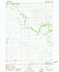
1983 Map of Southeast Pontiac
USGS Topo · Published 1983About this map
The Vermilion River snakes through this Central Illinois landscape, anchoring a series of small agricultural settlements and rural landmarks in the early 1980s. While the city of Pontiac and the town of Fairbury bookend the corners of the sheet, the interior is defined by smaller communities like McDowell, Lodemia, and Champlin. A notable density of private aviation infrastructure characterizes the era, with the Riverode Farms Landing Strip, Ziller Landing Strip, and Pick Landing Strip scattered across the township grid. For genealogists, the map preserves the locations of several smaller burial grounds, including Houder Cem, Patty Cem, and Avoca Cem. The presence of a large Quarry and Chautauqua Park suggests the dual industrial and recreational uses of the river valley during this period of Livingston County history.
Find a feature on this map
27 named features on this map. Tap any name to fly to it.
Don’t see what you’re looking for? This feature index may not catch every label — zoom into the map to look around manually.
Map Details
Editions of this 1983 Southeast Pontiac Map
This is the sole edition of this map. No revisions or reprints were ever made.
Other maps of this area

1935 · Pontiac
USGS Topo · 1:62,500

1939 · Pontiac
USGS Topo · 1:62,500

1947 · Sibley
USGS Topo · 1:62,500

1947 · Cullom
USGS Topo · 1:62,500

1949 · Cullom
USGS Topo · 1:62,500

1949 · Sibley
USGS Topo · 1:62,500

1957 · Colfax
USGS Topo · 1:62,500

1958 · Peoria
USGS Topo · 1:250,000

1961 · Peoria
USGS Topo · 1:250,000

1963 · Peoria
USGS Topo · 1:250,000