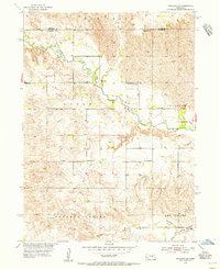
1954 Map of Spalding NW
USGS Topo · Published 1956About this map
The Cedar River meanders through the heart of this landscape, carving a fertile valley through the Nebraska Sandhills. This mid-century survey illustrates a rural world defined by small-scale cattle ranching and farming, where the social fabric was held together by a network of one-room schoolhouses strategically placed every few miles. Notable rural education sites include the distinctively named Corncob Sch and several numbered facilities such as School No 14 and School No 31.
Find a feature on this map
15 named features on this map. Tap any name to fly to it.
Don’t see what you’re looking for? This feature index may not catch every label — zoom into the map to look around manually.
Map Details
Editions of this 1954 Spalding NW Map
5 editions found
Other maps of this area

1954 · Greeley NE
USGS Topo · 1:24,000

1954 · Greeley
USGS Topo · 1:24,000

1954 · Spalding
USGS Topo · 1:24,000

1954 · Spalding SW
USGS Topo · 1:24,000

1954 · Spalding NW
USGS Topo · 1:24,000

1954 · Bartlett SE
USGS Topo · 1:24,000

1954 · Spalding SE
USGS Topo · 1:24,000

1955 · Broken Bow
USGS Topo · 1:250,000

1956 · Broken Bow
USGS Topo · 1:250,000

1960 · Spalding 2 SW
USGS Topo · 1:24,000