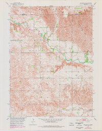
1954 Map of Spalding NW
USGS Topo · Published 1985About this map
The Cedar River cuts a prominent path through this 1950s landscape, flanked by the distinct Freeman Valley and Leo Valley to the south. This region of Greeley and Wheeler counties was mapped as part of the Missouri River Basin development program, documenting a rural Nebraska environment defined by its watercourses and a sparse network of early educational outposts.
Find a feature on this map
14 named features on this map. Tap any name to fly to it.
Don’t see what you’re looking for? This feature index may not catch every label — zoom into the map to look around manually.
Map Details
Editions of this 1954 Spalding NW Map
5 editions found
Other maps of this area

1954 · Greeley NE
USGS Topo · 1:24,000

1954 · Greeley
USGS Topo · 1:24,000

1954 · Spalding
USGS Topo · 1:24,000

1954 · Spalding SW
USGS Topo · 1:24,000

1954 · Spalding NW
USGS Topo · 1:24,000

1954 · Bartlett SE
USGS Topo · 1:24,000

1954 · Spalding SE
USGS Topo · 1:24,000

1955 · Broken Bow
USGS Topo · 1:250,000

1956 · Broken Bow
USGS Topo · 1:250,000

1960 · Spalding 2 SW
USGS Topo · 1:24,000