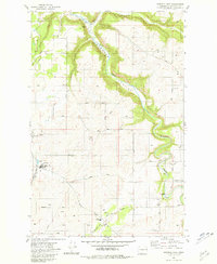
1981 Map of Spangle East
USGS Topo · Published 1981About this map
Hangman Creek Valley dominates the eastern landscape of this early 1980s revision, where the watercourse carves a deep path through the plateau. The town of Spangle sits on the western edge of the quadrangle, serving as an anchor for the surrounding agricultural community. The presence of Upper Columbia Academy and its associated Burlington Northern Landing Strip provides an interesting glimpse into the specialized infrastructure of the region.
Find a feature on this map
42 named features on this map. Tap any name to fly to it.
Don’t see what you’re looking for? This feature index may not catch every label — zoom into the map to look around manually.
Map Details
Editions of this 1981 Spangle East Map
2 editions found
Other maps of this area

1901 · Spokane
USGS Topo · 1:125,000

1903 · Oakesdale
USGS Topo · 1:125,000

1905 · Oakesdale
USGS Topo · 1:125,000

1949 · Greenacres
USGS Topo · 1:62,500

1950 · Spokane SE
USGS Topo · 1:24,000

1950 · Spokane SW
USGS Topo · 1:24,000

1950 · Spokane
USGS Topo · 1:62,500

1951 · Greenacres
USGS Topo · 1:62,500

1954 · Spangle
USGS Topo · 1:62,500

1954 · Fairfield
USGS Topo · 1:62,500