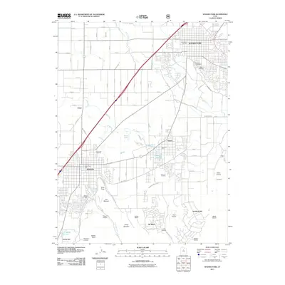
2011 Map of Spanish Fork
USGS Topo · Published 2011About this map
Spanish Fork and the surrounding Utah Valley settlements are anchored by an intricate system of water management including the Strawberry Highline Canal, Salem Canal, and Payson City Canal. This 2011 survey documents the residential expansion of Salem, Payson, and Elk Ridge toward the base of the Wasatch Range. The map provides significant genealogical value, locating the Spanish Fork City Cemetery, Salem City Cemetery, and Benjamin Cemetery. To the east, the terrain rises sharply toward Tithing Mountain and Little Mountain, where specialized sites like the Dream Mine and Leader Mine are situated near Water Canyon. The landscape is a mix of dense suburban development and high-altitude features such as Mollies Nipple and Picayune Canyon, reflecting the regional reliance on canyon drainage and engineered irrigation like Beer Creek and Peteetneet Creek to support agriculture and growing communities.
Find a feature on this map
90 named features on this map. Tap any name to fly to it.
Don’t see what you’re looking for? This feature index may not catch every label — zoom into the map to look around manually.
Map Details
Editions of this 2011 Spanish Fork Map
This is the sole edition of this map. No revisions or reprints were ever made.
Other maps of this area

1885 · Salt Lake
USGS Topo · 1:250,000

1885 · Manti
USGS Topo · 1:250,000

1895 · Manti
USGS Topo · 1:250,000

1948 · Spanish Fork
USGS Topo · 1:24,000

1948 · Springville
USGS Topo · 1:24,000

1948 · Provo
USGS Topo · 1:24,000

1949 · Provo
USGS Topo · 1:62,500

1949 · Spanish Fork Peak
USGS Topo · 1:24,000

1950 · Provo
USGS Topo · 1:24,000
1950 · Springville
USGS Topo · 1:24,000