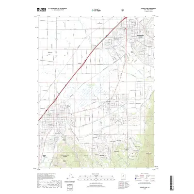
2020 Map of Spanish Fork
USGS Topo · Published 2020About this map
Spanish Fork and the surrounding southern Utah Valley floor exhibit a sophisticated network of water management, where the Spanish Fork River and Beer Cr are diverted into a complex system of irrigation. Key works like the Strawberry Highline Canal, Salem Canal, and Mill Race Canal illustrate the engineering required to sustain agricultural life in this arid climate. The landscape transitions sharply from the developed streets of Payson and Salem into the dramatic rises of the Wasatch Range to the southeast, where landmarks like Mollies Nipple and Tithing Mtn overlook the valley. This 2020 record also documents the civic and spiritual foundations of the community, including the Utah County Court House and numerous local burial grounds such as the Benjamin Cem and Salem City Cem. The southern edge reaches into the Uinta National Forest, marking the boundary between the expanding valley settlements and the protected canyons of the high country.
Find a feature on this map
139 named features on this map. Tap any name to fly to it.
Don’t see what you’re looking for? This feature index may not catch every label — zoom into the map to look around manually.
Map Details
Editions of this 2020 Spanish Fork Map
This is the sole edition of this map. No revisions or reprints were ever made.
Other maps of this area

1885 · Salt Lake
USGS Topo · 1:250,000

1885 · Manti
USGS Topo · 1:250,000

1895 · Manti
USGS Topo · 1:250,000

1948 · Spanish Fork
USGS Topo · 1:24,000

1948 · Springville
USGS Topo · 1:24,000

1948 · Provo
USGS Topo · 1:24,000

1949 · Provo
USGS Topo · 1:62,500

1949 · Spanish Fork Peak
USGS Topo · 1:24,000

1950 · Provo
USGS Topo · 1:24,000
1950 · Springville
USGS Topo · 1:24,000