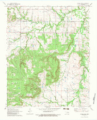
1971 Map of Spanish Peak
USGS Topo · Published 1983About this map
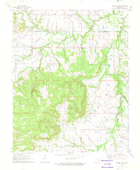
Spanish Peak rises as a prominent landmark in this 1970s landscape, marking a transition between the northern hills and the oil-rich plains of Okmulgee County. The map documents a rural economy heavily shaped by energy extraction, with a dense network of Oil Wells, Gas Wells, and a prominent Pipeline cutting through the terrain. Human settlement is anchored by small community centers like Hectorville and the southern edge of Glenpool, where local life is evidenced by the Liberty School, Hectorville Church, and the Snake Creek Church. Significant topographical features such as Rock Creek Canyon and the curiously named Hoot Owl Hollow provide contrast to the industrial infrastructure. Traces of local family history appear at the Bruner Cemetery, while landmarks like Dude Ranch Hill and a small Landing Strip reflect the diverse land use of the era.
Find a feature on this map
31 named features on this map. Tap any name to fly to it.
Don’t see what you’re looking for? This feature index may not catch every label — zoom into the map to look around manually.
Map Details
Editions of this 1971 Spanish Peak Map
2 editions found
Other maps of this area

1896 · Okmulgee
USGS Topo · 1:125,000

1900 · Okmulgee
USGS Topo · 1:125,000

1901 · Nuyaka
USGS Topo · 1:125,000

1914 · Kiefer
USGS Topo · 1:62,500

1916 · Kiefer
USGS Topo · 1:62,500

1946 · Fort Smith
USGS Topo · 1:250,000

1954 · Oklahoma City
USGS Topo · 1:250,000

1957 · Leonard
USGS Topo · 1:24,000
1957 · Bixby
USGS Topo · 1:24,000

1957 · Oklahoma City
USGS Topo · 1:250,000