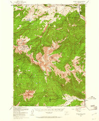
1950 Map of Spanish Peaks
USGS Topo · Published 1961About this map
Gallatin Peak anchors the high country of the Spanish Peaks in this mid-century survey of the high-altitude wilderness bridging Madison and Gallatin counties. The landscape is defined by its glacial lakes and sharp ridgelines, from the Jerome Rock Lakes to the clusters of the Spanish Lakes and Chilled Lakes. The presence of the Spanish Creek Ranger Station and the Andesite Lookout Tower underscores the importance of resource management and fire watch in the Gallatin National Forest at this time.
Find a feature on this map
81 named features on this map. Tap any name to fly to it.
Don’t see what you’re looking for? This feature index may not catch every label — zoom into the map to look around manually.
Map Details
Editions of this 1950 Spanish Peaks Map
4 editions found
Other maps of this area

1888 · Three Forks
USGS Topo · 1:250,000

1894 · Three Forks
USGS Topo · 1:250,000

1895 · Three Forks
USGS Topo · 1:250,000

1947 · Bozeman
USGS Topo · 1:250,000

1948 · Bozeman
USGS Topo · 1:250,000

1949 · Anceney
USGS Topo · 1:62,500

1949 · Ennis
USGS Topo · 1:62,500

1949 · Norris
USGS Topo · 1:62,500

1950 · Cameron
USGS Topo · 1:62,500

1950 · Spanish Peaks
USGS Topo · 1:62,500
Featured Places
- Big Sky, MT
- Big Sky Mountain Village, MT
- Big Sky Canyon Village, MT
- Big Sky Meadow Village, MT
- Beacon Point, MT