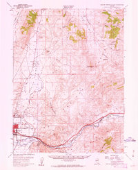
1957 Map of Spanish Springs Valley
USGS Topo · Published 1963About this map
Spanish Springs Valley serves as a stark corridor between the high peaks of the Pah Rah Range and the industrializing lowlands of the Truckee River during the late 1950s. The northern portion of the quadrangle is defined by rural ranching life at Home Ranch and Wilcox Ranch, alongside the isolated aviation outpost of the Reno Sky Ranch. To the south, the landscape transforms into a hub of mid-century infrastructure. The growing community of Sparks is shown with its early street grids, the North Truckee Sch, and significant utilities like the KOH Radio Towers and Sewage Disposal plant. Following the Southern Pacific tracks and the river eastward, the map documents small settlements and points of interest such as Glendale, Hafed, and Mustang, illustrating the vital transportation link connecting the Reno area to the eastern canyons.
Find a feature on this map
50 named features on this map. Tap any name to fly to it.
Don’t see what you’re looking for? This feature index may not catch every label — zoom into the map to look around manually.
Map Details
Editions of this 1957 Spanish Springs Valley Map
3 editions found

Other maps of this area

1890 · Wadsworth
USGS Topo · 1:125,000

1891 · Carson
USGS Topo · 1:125,000

1891 · Wabuska
USGS Topo · 1:125,000

1891 · Reno
USGS Topo · 1:125,000

1892 · Wadsworth
USGS Topo · 1:125,000

1893 · Carson
USGS Topo · 1:125,000

1893 · Reno
USGS Topo · 1:125,000

1894 · Wadsworth
USGS Topo · 1:125,000

1894 · Wabuska
USGS Topo · 1:125,000

1950 · Virginia City
USGS Topo · 1:62,500