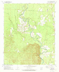
1971 Map of Sparkman NW
USGS Topo · Published 1973About this map
The Ouachita River meanders dramatically through this riverine landscape, defining the boundary between Clark and Dallas counties. In the early 1970s, this area remained largely rural, characterized by its dense network of waterways and oxbow formations such as Round Lake and Long Lake. Small communities and agricultural pockets like Fairview and Shakertown anchor the higher ground away from the floodplains. Local life is centered around landmarks such as Rock Springs Church and Union Grove Church, while the Centerpoint Cemetery provides a genealogical touchstone for the region. Historical river crossings are evidenced by Nix Ferry on the Ouachita, while numerous tributaries including Terre Noire Creek, Deceiver Creek, and Cypress Creek drainage patterns illustrate the complex hydrology of the Arkansas timberlands.
Find a feature on this map
20 named features on this map. Tap any name to fly to it.
Don’t see what you’re looking for? This feature index may not catch every label — zoom into the map to look around manually.
Map Details
Editions of this 1971 Sparkman NW Map
2 editions found
Other maps of this area

1901 · Gurdon
USGS Topo · 1:125,000

1903 · Camden
USGS Topo · 1:125,000

1953 · El Dorado
USGS Topo · 1:250,000

1955 · Little Rock
USGS Topo · 1:250,000

1956 · Little Rock
USGS Topo · 1:250,000

1957 · El Dorado
USGS Topo · 1:250,000

1958 · El Dorado
USGS Topo · 1:250,000

1959 · Arkadelphia
USGS Topo · 1:24,000

1960 · El Dorado
USGS Topo · 1:250,000

1960 · Little Rock
USGS Topo · 1:250,000