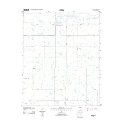
2012 Map of Sparks
USGS Topo · Published 2012About this map
Sparks serves as the central hub of this 2012 landscape, where local streets like Broadway St and McLaughlin Ave define the small-town grid. The surrounding Lincoln County countryside is heavily shaped by water management, featuring a series of numbered flood-control structures along the Quapaw Cr drainage, such as Quapaw Cr Site 44 Reservoir and Quapaw Cr Site 2 Reservoir. To the south, the settlement of Payson sits near the winding course of Little Sand Cr. The rural character of the area is underscored by family and community landmarks, including White Dove Cem and Sunnyside Cem. The northern boundary is defined by the larger channel of the Deep Fork, while numerous smaller tributaries like Hogshooter Cr and Breakfast Cr dissect the terrain, illustrating the complex hydrology of the Oklahoma Cross Timbers region.
Find a feature on this map
43 named features on this map. Tap any name to fly to it.
Don’t see what you’re looking for? This feature index may not catch every label — zoom into the map to look around manually.
Map Details
Editions of this 2012 Sparks Map
This is the sole edition of this map. No revisions or reprints were ever made.
Other maps of this area

1896 · Seminole and Prague
USGS Topo · 1:125,000

1905 · Chandler
USGS Topo · 1:62,500

1907 · Chandler
USGS Topo · 1:62,500

1909 · Shawnee
USGS Topo · 1:62,500

1929 · Stroud
USGS Topo · 1:62,500

1932 · Stroud
USGS Topo · 1:62,500

1954 · Oklahoma City
USGS Topo · 1:250,000

1957 · Oklahoma City
USGS Topo · 1:250,000

1963 · Oklahoma City
USGS Topo · 1:250,000
1967 · Aydelotte
USGS Topo · 1:24,000