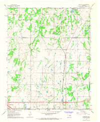
1967 Map of Aydelotte
USGS Topo · Published 1968About this map
The Lincoln Co Pottawatomie Co boundary line bisects this landscape, which is defined by a transitional economy of agriculture and extraction during the late 1960s. The Atchison Topeka and Santa Fe railroad corridor serves as a primary north-south spine, passing through the settlement of Aydelotte and connecting toward Meeker in the north. The southern portion of the quadrangle shows the influence of the petroleum industry with a designated Oil Field and numerous pipelines cutting across the terrain.
Find a feature on this map
26 named features on this map. Tap any name to fly to it.
Don’t see what you’re looking for? This feature index may not catch every label — zoom into the map to look around manually.
Map Details
Editions of this 1967 Aydelotte Map
3 editions found
Other maps of this area

1896 · Seminole and Prague
USGS Topo · 1:125,000

1898 · Purcell
USGS Topo · 1:125,000

1905 · Chandler
USGS Topo · 1:62,500

1907 · Chandler
USGS Topo · 1:62,500

1909 · Shawnee
USGS Topo · 1:62,500

1909 · Luther
USGS Topo · 1:62,500

1930 · McLoud
USGS Topo · 1:62,500

1954 · Oklahoma City
USGS Topo · 1:250,000

1957 · Oklahoma City
USGS Topo · 1:250,000

1963 · Oklahoma City
USGS Topo · 1:250,000