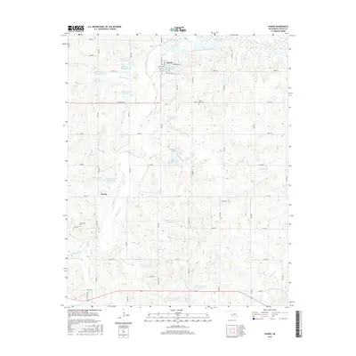
2016 Map of Sparks
USGS Topo · Published 2016About this map
The town of Sparks and the community of Payson anchor this central Oklahoma landscape, where the water management of the Quapaw Creek watershed is the defining modern feature. A vast series of numbered flood control reservoirs, such as Quapaw Creek Site 1 Reservoir and Quapaw Cr Site 7 Reservoir, are distributed across the drainage basins of Quapaw Creek and its many tributaries. This complex hydrological network reveals a coordinated effort to manage the local environment and agricultural land. In the northeast, the Deep Fork River creates a broad, marshy floodplain. Cultural history is marked by the presence of White Dove Cemetery and Sunnyside Cemetery, serving as local genealogical anchors. The terrain is further etched by numerous named streams including Hogshooter Creek, Breakfast Creek, and Little Sand Creek, which weave through the section-line road grid.
Find a feature on this map
58 named features on this map. Tap any name to fly to it.
Don’t see what you’re looking for? This feature index may not catch every label — zoom into the map to look around manually.
Map Details
Editions of this 2016 Sparks Map
This is the sole edition of this map. No revisions or reprints were ever made.
Other maps of this area

1896 · Seminole and Prague
USGS Topo · 1:125,000

1905 · Chandler
USGS Topo · 1:62,500

1907 · Chandler
USGS Topo · 1:62,500

1909 · Shawnee
USGS Topo · 1:62,500

1929 · Stroud
USGS Topo · 1:62,500

1932 · Stroud
USGS Topo · 1:62,500

1954 · Oklahoma City
USGS Topo · 1:250,000

1957 · Oklahoma City
USGS Topo · 1:250,000

1963 · Oklahoma City
USGS Topo · 1:250,000
1967 · Aydelotte
USGS Topo · 1:24,000