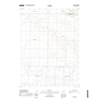
2017 Map of Sparks SE
USGS Topo · Published 2017About this map
The Niobrara National Scenic River corridor cuts across the northeast corner of this Cherry County landscape, where the Niobrara River winds through a narrow valley. South of this protected waterway, the terrain is defined by the high, undulating tablelands and complex hydrology of the Sandhills. This 2017 survey details the branching drainage of Fairfield Cr in the south and the winding course of Lost Cr to the east, illustrating how these seasonal watercourses carve into the plateau. The map highlights a largely unsettled expanse of Nebraska rangeland, organized by the township and range lines of the Public Land Survey System, including t33n r26w and t32n r25w. It serves as a precise record of contemporary land management and natural water features in a region where the vastness of the prairie meets the biologically diverse Niobrara valley.
Find a feature on this map
10 named features on this map. Tap any name to fly to it.
Don’t see what you’re looking for? This feature index may not catch every label — zoom into the map to look around manually.
Map Details
Editions of this 2017 Sparks SE Map
This is the sole edition of this map. No revisions or reprints were ever made.
Other maps of this area

1950 · Norden
USGS Topo · 1:62,500

1950 · Sparks
USGS Topo · 1:62,500

1950 · Wood Lake
USGS Topo · 1:62,500

1950 · Arabia
USGS Topo · 1:62,500

1952 · Norden
USGS Topo · 1:62,500

1957 · Valentine
USGS Topo · 1:250,000

1959 · Valentine
USGS Topo · 1:250,000
1983 · Sparks
USGS Topo · 1:24,000
1983 · Muleshoe Creek
USGS Topo · 1:24,000
1983 · Thatcher
USGS Topo · 1:24,000