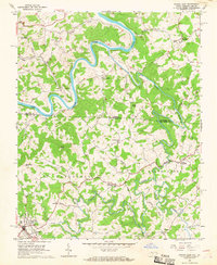
1966 Map of Sparta East
USGS Topo · Published 1968About this map
New River and Little River carve deep, winding paths through this section of the Blue Ridge along the Virginia-North Carolina border. The 1960s landscape is defined by its rural crossroads and high-elevation peaks, including Bald Knob and Doughton Mtn. The town of Sparta serves as the primary hub in the southwest corner, while the surrounding countryside is dotted with small community centers like Baywood and Peach Bottom. Local life is anchored by numerous country churches, such as Pleasant Grove Ch and Glade Creek Ch, alongside small family landmarks like Hooker and McKenney Hill. The survey highlights a period when local navigation relied heavily on junctions like Blevins Crossroads and Edwards Crossroads, with the meandering river branches dictating the layout of early roads like Hooker Road.
Find a feature on this map
39 named features on this map. Tap any name to fly to it.
Don’t see what you’re looking for? This feature index may not catch every label — zoom into the map to look around manually.
Map Details
Editions of this 1966 Sparta East Map
3 editions found
Other maps of this area

1889 · Hillsville
USGS Topo · 1:125,000

1889 · Wytheville
USGS Topo · 1:125,000

1889 · Wilkesboro
USGS Topo · 1:125,000

1891 · Wilkesboro
USGS Topo · 1:125,000

1891 · Yadkinville
USGS Topo · 1:125,000

1892 · Hillsville
USGS Topo · 1:125,000

1892 · Wytheville
USGS Topo · 1:125,000

1893 · Yadkinville
USGS Topo · 1:125,000

1896 · Hillsville
USGS Topo · 1:125,000

1930 · Independence
USGS Topo · 1:48,000