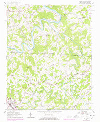
1966 Map of Sparta East
USGS Topo · Published 1978About this map
The New River meanders deeply through the borderlands of North Carolina and Virginia, defining a landscape of high ridges and narrow creek bottoms. In the late 1960s, this area of Grayson Co Alleghany Co County was characterized by small, dispersed rural settlements and crossroads communities. The town of Sparta sits at the southwestern edge of the sheet, serving as a hub for the surrounding agricultural district. The terrain is marked by significant elevations such as Bald Knob and Doughton Mtn, while several small community churches, including Pleasant Home Ch and Glade Creek Ch, anchor the social geography of the townships.
Find a feature on this map
40 named features on this map. Tap any name to fly to it.
Don’t see what you’re looking for? This feature index may not catch every label — zoom into the map to look around manually.
Map Details
Editions of this 1966 Sparta East Map
3 editions found
Other maps of this area

1889 · Hillsville
USGS Topo · 1:125,000

1889 · Wytheville
USGS Topo · 1:125,000

1889 · Wilkesboro
USGS Topo · 1:125,000

1891 · Wilkesboro
USGS Topo · 1:125,000

1891 · Yadkinville
USGS Topo · 1:125,000

1892 · Hillsville
USGS Topo · 1:125,000

1892 · Wytheville
USGS Topo · 1:125,000

1893 · Yadkinville
USGS Topo · 1:125,000

1896 · Hillsville
USGS Topo · 1:125,000

1930 · Independence
USGS Topo · 1:48,000