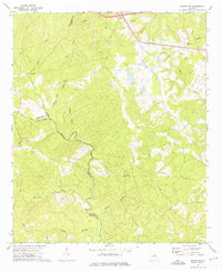
1972 Map of Sparta NE
USGS Topo · Published 1975About this map
Powelton sits near the tri-county intersection of Taliaferro, Warren, and Hancock counties, marking a significant point of historical interest in this rural Georgia landscape. The area is defined by the winding course of the Ogeechee River, which serves as a natural boundary as it flows southward. Local life in the early 1970s is anchored by several rural landmarks, including Greenwood Ch, New Hope Ch, and Rocky Branch Ch, alongside small family plots marked simply as Cem. The terrain is deeply carved by a network of waterways like Beaverdam Creek, Rocky Creek, and Williams Creek, illustrating the complex drainage patterns of the Piedmont region. Above the creek valleys, the Barnett Lookout Tower and a Radio Tower near Powelton highlight the high points of the topography, while Georgia 22 provides the primary asphalt artery through the wooded hills.
Find a feature on this map
24 named features on this map. Tap any name to fly to it.
Don’t see what you’re looking for? This feature index may not catch every label — zoom into the map to look around manually.
Map Details
Editions of this 1972 Sparta NE Map
2 editions found
Other maps of this area

1906 · Crawfordville
USGS Topo · 1:125,000

1953 · Athens
USGS Topo · 1:250,000

1958 · Athens
USGS Topo · 1:250,000

1959 · Athens
USGS Topo · 1:250,000

1963 · Athens
USGS Topo · 1:250,000

1966 · Crawfordville
USGS Topo · 1:24,000

1971 · Beall Springs
USGS Topo · 1:24,000

1972 · Sharon
USGS Topo · 1:24,000

1972 · Sparta NW
USGS Topo · 1:24,000
1972 · Cadley
USGS Topo · 1:24,000