1986 Map of Spartanburg
USGS Topo · Published 1989About this map
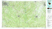
Spartanburg and Rock Hill anchor this mid-1980s look at the Piedmont region, where the industrial corridors of the Upstate meet the rural expanses of the Sumter National Forest. The landscape is defined by the southeasterly flow of major river systems including the Broad River, Enoree River, and Pacolet River, which historically powered the textile mills of the region. Distinctive landmarks like Bald Rock and Worth Mountain rise above the rolling terrain, while large protected tracts such as Croft State Park and Rose Hill State Park preserve significant portions of the wooded countryside. Small crossroads and rail-aligned settlements like Brattonville, Wilkinsville, and Lockhart dot the map between the larger hubs of Union and Chester. Genealogists and local historians can trace legacy sites such as Goodwins Mine or the former military grounds of Camp Croft, providing a detailed view of the area's transition from an agrarian and mining economy to a modern industrial and recreational landscape.
Find a feature on this map
113 named features on this map. Tap any name to fly to it.
Don’t see what you’re looking for? This feature index may not catch every label — zoom into the map to look around manually.
Map Details
Editions of this 1986 Spartanburg Map
2 editions found

Other maps of this area

1892 · Abbeville
USGS Topo · 1:125,000

1904 · Columbia
USGS Topo · 1:125,000

1905 · Charlotte
USGS Topo · 1:48,000

1906 · Kings Mountain
USGS Topo · 1:62,500

1907 · Sharon
USGS Topo · 1:62,500

1907 · Saluda
USGS Topo · 1:125,000

1907 · Charlotte
USGS Topo · 1:62,500

1908 · Kings Mountain
USGS Topo · 1:62,500

1909 · Gaffney
USGS Topo · 1:62,500

1935 · Greer
USGS Topo · 1:48,000