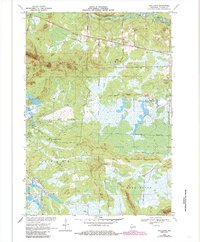
1970 Map of Spaulding
USGS Topo · Published 1985About this map
Cranberry Bogs and intricate water-management networks define this portion of central Wisconsin. The landscape is structured by the Green Bay and Western Railroad Grade and the Old Railroad Grade, which intersect near the historic rail points of Lapham Junction and Eleva Station. These remnants of the timber and transport era sit alongside the natural contours of the Black River and its East Fork. The map reveals a transition into the managed wilderness of the Meadow Valley State Wildlife Management Area, where artificial waterways like the North Floater Ditch and South Floater Ditch intersect the lowlands. Rising above the marshes and commercial bogs are prominent local landmarks such as Saddle Mound, Sugarloaf Mound, and Bear Bluff, the latter featuring Hunters Peak and Drescher Island.
Find a feature on this map
32 named features on this map. Tap any name to fly to it.
Don’t see what you’re looking for? This feature index may not catch every label — zoom into the map to look around manually.
Map Details
Editions of this 1970 Spaulding Map
2 editions found

Other maps of this area

1947 · Millston
USGS Topo · 1:62,500

1949 · Millston
USGS Topo · 1:62,500

1953 · Eau Claire
USGS Topo · 1:250,000

1957 · City Point
USGS Topo · 1:48,000

1958 · Eau Claire
USGS Topo · 1:250,000

1958 · Hatfield
USGS Topo · 1:48,000

1958 · Wyeville
USGS Topo · 1:48,000

1964 · Eau Claire
USGS Topo · 1:250,000

1970 · City Point NE
USGS Topo · 1:24,000
1970 · Mather
USGS Topo · 1:24,000