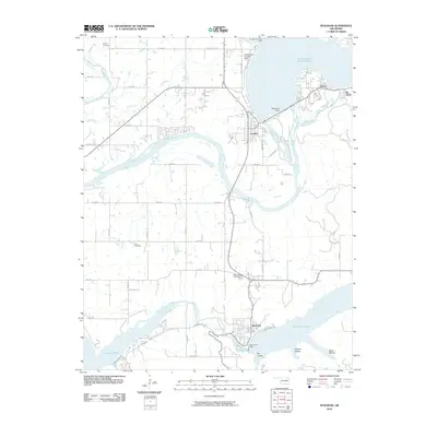
2010 Map of Spavinaw
USGS Topo · Published 2010About this map
Pensacola Dam stands as the dominant engineering feature of this landscape, holding back the waters of Grand Lake O' The Cherokees just north of the community of Langley. This 2010 survey illustrates a complex hydraulic network where the Neosho River feeds into Lake Hudson to the south, while the Spavinaw Dam creates the expansive Spavinaw Lake at the town of Spavinaw. The terrain is marked by significant elevation changes, particularly around Tag Hollow, Chicken Hollow, and Black Hollow near the eastern shoreline. Settlement patterns are concentrated near these water resources, with smaller communities like Disney and Tia Juana positioned along the lake's edge. Local history is preserved in several burial grounds, including the Military Cemetery in the northwest and West Cemetery near the center of the quadrangle. The map detail reflects a region defined by its mid-century reservoir projects and the tourism and infrastructure that followed.
Find a feature on this map
43 named features on this map. Tap any name to fly to it.
Don’t see what you’re looking for? This feature index may not catch every label — zoom into the map to look around manually.
Map Details
Editions of this 2010 Spavinaw Map
This is the sole edition of this map. No revisions or reprints were ever made.
Other maps of this area

1896 · Pryor
USGS Topo · 1:125,000

1899 · Siloam Springs
USGS Topo · 1:125,000

1901 · Vinita
USGS Topo · 1:125,000

1901 · Pryor
USGS Topo · 1:125,000

1903 · Siloam Springs
USGS Topo · 1:125,000

1904 · Siloam Springs
USGS Topo · 1:125,000

1907 · Wyandotte
USGS Topo · 1:125,000

1909 · Wyandotte
USGS Topo · 1:125,000

1913 · Vinita
USGS Topo · 1:125,000

1954 · Tulsa
USGS Topo · 1:250,000