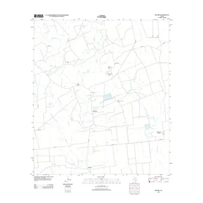
2013 Map of Speaks
USGS Topo · Published 2013About this map
The Navidad River and its numerous tributaries, including Sandies Cr and Goldenrod Cr, dominate this rural Lavaca County landscape. Local infrastructure is anchored by the small communities of Speaks and Seclusion, alongside the industrial footprint of the Provident City area. This 2013 survey illustrates the continued importance of the energy sector to the local economy, marked by the expansive Provident City Gas Field, the Wilcox Refinery, and the Provident City Refinery. For genealogists and local historians, the map identifies specific family landmarks such as Hartt Cem near the river and Bright Cem further east. The network of county roads, such as Cord 14 and FM 530, connects these remote settlements and industrial sites across a terrain defined by subtle drainage basins and agricultural land.
Find a feature on this map
34 named features on this map. Tap any name to fly to it.
Don’t see what you’re looking for? This feature index may not catch every label — zoom into the map to look around manually.
Map Details
Editions of this 2013 Speaks Map
This is the sole edition of this map. No revisions or reprints were ever made.
Other maps of this area

1953 · Seguin
USGS Topo · 1:250,000

1958 · Seguin
USGS Topo · 1:250,000

1962 · Sublime
USGS Topo · 1:24,000

1962 · Hallettsville SE
USGS Topo · 1:24,000

1964 · Cordele
USGS Topo · 1:24,000

1964 · Morales
USGS Topo · 1:24,000

1964 · Speaks
USGS Topo · 1:24,000
1965 · Sheridan NE
USGS Topo · 1:24,000

1965 · Ganado NE
USGS Topo · 1:24,000

1965 · Sheridan SE
USGS Topo · 1:24,000