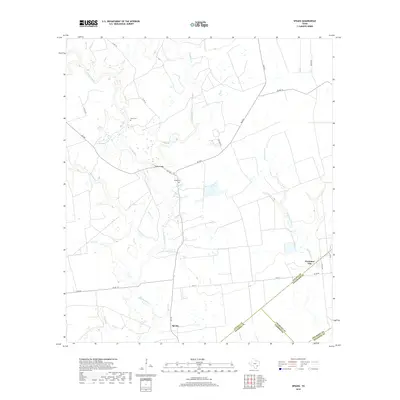
2019 Map of Speaks
USGS Topo · Published 2019About this map
The Navidad River winds through this coastal prairie landscape where the borders of Lavaca, Colorado, and Jackson counties meet. The settlement of Speaks serves as a local anchor near the southern edge, while the rural community of Provident City occupies the eastern portion of the quadrangle. For genealogists and local historians, the presence of the Hartt Cem and Bright Cem offers primary evidence of early family holdings in the region.
Find a feature on this map
35 named features on this map. Tap any name to fly to it.
Don’t see what you’re looking for? This feature index may not catch every label — zoom into the map to look around manually.
Map Details
Editions of this 2019 Speaks Map
This is the sole edition of this map. No revisions or reprints were ever made.
Other maps of this area

1953 · Seguin
USGS Topo · 1:250,000

1958 · Seguin
USGS Topo · 1:250,000

1962 · Sublime
USGS Topo · 1:24,000

1962 · Hallettsville SE
USGS Topo · 1:24,000

1964 · Cordele
USGS Topo · 1:24,000

1964 · Morales
USGS Topo · 1:24,000

1964 · Speaks
USGS Topo · 1:24,000
1965 · Sheridan NE
USGS Topo · 1:24,000

1965 · Ganado NE
USGS Topo · 1:24,000

1965 · Sheridan SE
USGS Topo · 1:24,000