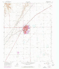
1962 Map of Spearman
USGS Topo · Published 1977About this map
The Spearman Gas and Oil Field dominates the High Plains landscape of Hansford County, where a dense network of wells and pipelines surrounds the hub of Spearman. This map captures the town as a regional center of the Texas Panhandle, anchored by the Court House and County Hosp. The industrial character of the era is evidenced by the prominent Atchison Topeka and Santa Fe railroad line cutting diagonally across the terrain toward the northeast. Social and community life in the mid-century are well-documented through landmarks like the Rodeo Grounds, Drive-in Theater, and Womble Park. The presence of the Spearman Airport and several local schools, including the High School and Elementary Sch, underscores the post-war growth of this rural agricultural and energy-producing community along Horse Creek.
Find a feature on this map
16 named features on this map. Tap any name to fly to it.
Don’t see what you’re looking for? This feature index may not catch every label — zoom into the map to look around manually.
Map Details
Editions of this 1962 Spearman Map
2 editions found
Other maps of this area

1954 · Perryton
USGS Topo · 1:250,000

1958 · Perryton
USGS Topo · 1:250,000

1962 · Kimball
USGS Topo · 1:24,000

1962 · Hansford
USGS Topo · 1:24,000

1962 · Waka SW
USGS Topo · 1:24,000

1962 · Spearman
USGS Topo · 1:24,000

1973 · Waka
USGS Topo · 1:24,000

1973 · Spearman NE
USGS Topo · 1:24,000

1973 · Spearman SE
USGS Topo · 1:24,000
1974 · Holt
USGS Topo · 1:24,000