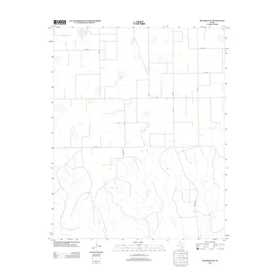
2012 Map of Spearman SE
USGS Topo · Published 2012About this map
Intermittent creek beds and a rigid grid of rural roads characterize this portion of Hutchinson County in the Texas Panhandle. The landscape is dominated by the seasonal drainages of Johns Cr and Willow Cr in the south, while the northern half is defined by the rectilinear layout of county infrastructure. The intersection of Fm-281 and north-south routes like Co RD 2 and Co RD 3 reveal the systematic division of agricultural lands typical of this era. Water is a defining yet scarce feature, represented by the dendritic patterns of the Pats Cr system, including its E Fork Pats Cr. The map captures the quiet, dispersed nature of Texas ranch and farm country, where named landmarks like Brainard Rd serve as the primary navigational anchors across a territory of cattle and crops.
Find a feature on this map
15 named features on this map. Tap any name to fly to it.
Don’t see what you’re looking for? This feature index may not catch every label — zoom into the map to look around manually.
Map Details
Editions of this 2012 Spearman SE Map
This is the sole edition of this map. No revisions or reprints were ever made.
Other maps of this area

1954 · Perryton
USGS Topo · 1:250,000

1954 · Amarillo
USGS Topo · 1:250,000

1958 · Perryton
USGS Topo · 1:250,000

1958 · Amarillo
USGS Topo · 1:250,000

1962 · Spearman
USGS Topo · 1:24,000

1971 · Dry Creek North
USGS Topo · 1:24,000

1971 · Garden Springs
USGS Topo · 1:24,000

1973 · Sourdough Creek SW
USGS Topo · 1:24,000

1973 · Spearman NE
USGS Topo · 1:24,000

1973 · Sourdough Creek NW
USGS Topo · 1:24,000