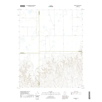
2019 Map of Spearman SE
USGS Topo · Published 2019About this map
The intersection of four Texas Panhandle counties—Hansford, Ochiltree, Hutchinson, and Roberts—marks the center of this landscape where the flat High Plains meet the eroded breaks of the Canadian River watershed. The northern portion of the map is dominated by the geometric precision of county roads like Co Rd BB and Co Rd CC, reflecting the region’s agricultural grid and ranching heritage. South of Fm 281, the terrain shifts abruptly as the plateau gives way to complex drainage networks. Watercourses such as Johns Creek, Willow Cr, and the branching arms of Pats Creek have carved deep into the earth. The winding path of Brainard Rd and Pats Creek R follow these natural contours, illustrating how the physical geography of the breaks dictates transportation and land use in this sparsely populated border region.
Find a feature on this map
21 named features on this map. Tap any name to fly to it.
Don’t see what you’re looking for? This feature index may not catch every label — zoom into the map to look around manually.
Map Details
Editions of this 2019 Spearman SE Map
This is the sole edition of this map. No revisions or reprints were ever made.
Other maps of this area

1954 · Perryton
USGS Topo · 1:250,000

1954 · Amarillo
USGS Topo · 1:250,000

1958 · Perryton
USGS Topo · 1:250,000

1958 · Amarillo
USGS Topo · 1:250,000

1962 · Spearman
USGS Topo · 1:24,000

1971 · Dry Creek North
USGS Topo · 1:24,000

1971 · Garden Springs
USGS Topo · 1:24,000

1973 · Sourdough Creek SW
USGS Topo · 1:24,000

1973 · Spearman NE
USGS Topo · 1:24,000

1973 · Sourdough Creek NW
USGS Topo · 1:24,000