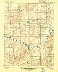
1894 Map of Spearville
USGS Topo · Published 1949About this map
The Arkansas River carves a deep diagonal through this late 19th-century landscape, serving as a primary geographic anchor for the region's development. Two major rail corridors define the settlement patterns of the era, with the Atchison Topeka and Santa Fe Railroad running across the northern half, connecting Spearville, Wright, and Offerle. To the south, the Chicago Kansas and Nebraska Railroad supports towns like Bucklin and Kingsdown. This grid-based land survey illustrates the transition from open prairie to structured agricultural townships such as Sodville, Bloom, and Wheatland. Small creek systems, including Mulberry Creek and Coon Creek, provide natural drainage through the undulating terrain, while several small rail stops like Bellefont and Fonda mark the early infrastructure of the central Kansas plains.
Find a feature on this map
32 named features on this map. Tap any name to fly to it.
Don’t see what you’re looking for? This feature index may not catch every label — zoom into the map to look around manually.
Map Details
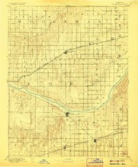
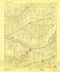
Editions of this 1894 Spearville Map
4 editions found
Other maps of this area

1889 · Larned
USGS Topo · 1:125,000

1889 · Kinsley
USGS Topo · 1:125,000

1891 · Larned
USGS Topo · 1:125,000

1892 · Ness
USGS Topo · 1:125,000

1892 · Kinsley
USGS Topo · 1:125,000

1892 · Meade
USGS Topo · 1:125,000

1892 · Dodge
USGS Topo · 1:125,000

1892 · Spearville
USGS Topo · 1:125,000

1892 · Coldwater
USGS Topo · 1:125,000

1894 · Spearville
USGS Topo · 1:125,000