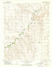
1972 Map of Spearville NE
USGS Topo · Published 1974About this map
Saw Log Creek meanders through the central terrain of this Western Kansas landscape, carving a distinct path through the townships of Sawlog, Sterling, and Spearville. The 1970s land use reflects a mix of traditional agricultural infrastructure and emerging industrial interests. Evidence of the region's ranching and utility footprint is found in the large Feed Lot and a prominent Radio Tower. Subsurface resources are equally vital to the local economy, marked by an active Oil Field and scattered Oil Wells. The map also captures the presence of the Jetmore Municipal Airport in the northwest corner, while numerous resource extraction sites like the Caliche Pit and Gravel Pit suggest localized mining for road building and construction material during this era.
Find a feature on this map
12 named features on this map. Tap any name to fly to it.
Don’t see what you’re looking for? This feature index may not catch every label — zoom into the map to look around manually.
Map Details
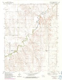
Editions of this 1972 Spearville NE Map
2 editions found
Other maps of this area

1892 · Ness
USGS Topo · 1:125,000

1892 · Spearville
USGS Topo · 1:125,000

1894 · Spearville
USGS Topo · 1:125,000

1894 · Ness
USGS Topo · 1:125,000

1955 · Great Bend
USGS Topo · 1:250,000

1955 · Pratt
USGS Topo · 1:250,000

1957 · Great Bend
USGS Topo · 1:250,000

1958 · Great Bend
USGS Topo · 1:250,000

1959 · Pratt
USGS Topo · 1:250,000

1969 · Jetmore
USGS Topo · 1:24,000