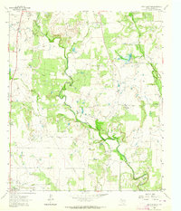
1962 Map of Speck Mountain
USGS Topo · Published 1964About this map
Home Creek winds across this Central Texas landscape, defining the rural character of Coleman County in the early 1960s. The settlement at Rockwood serves as a primary point of interest, while smaller locales like Speck and the La Vista Ranch are situated among the undulating terrain. A distinct industrial presence is evident throughout the quadrangle, marked by numerous Oil Wells, a Gas Well, and several Drill Hole sites, reflecting the mid-century energy production in the region.
Find a feature on this map
17 named features on this map. Tap any name to fly to it.
Don’t see what you’re looking for? This feature index may not catch every label — zoom into the map to look around manually.
Map Details
Editions of this 1962 Speck Mountain Map
2 editions found
Other maps of this area

1887 · Coleman
USGS Topo · 1:125,000

1889 · Coleman
USGS Topo · 1:125,000

1894 · Brady
USGS Topo · 1:125,000

1924 · Brady 2-a
USGS Topo · 1:48,000

1925 · Brady 2-b
USGS Topo · 1:48,000

1925 · Brady 1-b
USGS Topo · 1:48,000

1928 · Mercury
USGS Topo · 1:62,500

1928 · Waldrip
USGS Topo · 1:62,500

1950 · Mercury
USGS Topo · 1:62,500

1954 · Brownwood
USGS Topo · 1:250,000