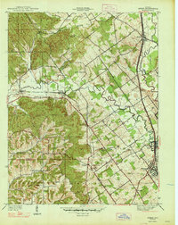
1947 Map of Speed
USGS Topo · Published 1947About this map
The Clark Military Grant boundary slashes diagonally across this landscape, separating the older land distribution patterns from the structured townships of Monroe, Union, and Silver Creek. This late 1930s survey (published in 1947) captures a rural Indiana transition where traditional farming communities like Bennettsville and St Joseph Hill are anchored by landmarks such as Ebenezer Ch and St Joseph Cem. The eastern corridor is defined by the Pennsylvania railroad, which fostered the growth of Memphis, Sellersburg, and the industrial site at Speed. The presence of several country schools, including College Hill Sch and Warmans Sch, along with the Narrow Gage and Indiana Electric lines, illustrates the dense network of local infrastructure that supported the region before post-war modernization. Significant natural features like the Guernsey Knobs and the winding Big Muddy Fork provide the backdrop for these long-established family settlements.
Find a feature on this map
52 named features on this map. Tap any name to fly to it.
Don’t see what you’re looking for? This feature index may not catch every label — zoom into the map to look around manually.
Map Details
Editions of this 1947 Speed Map
2 editions found

Other maps of this area

1905 · Prospect
USGS Topo · 1:62,500

1912 · Prospect
USGS Topo · 1:62,500

1937 · Jeffersonville
USGS Topo · 1:24,000

1937 · Charlestown
USGS Topo · 1:24,000

1938 · Speed
USGS Topo · 1:24,000

1939 · New Albany
USGS Topo · 1:24,000

1939 · Georgetown
USGS Topo · 1:24,000

1941 · Borden
USGS Topo · 1:24,000

1946 · Jeffersonville
USGS Topo · 1:24,000

1946 · New Albany
USGS Topo · 1:24,000