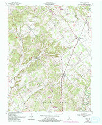
1956 Map of Otisco
USGS Topo · Published 1993About this map
The Clark Military Grant defines much of the land organization in this section of Indiana, where historical property lines contrast with standard township grids. The Baltimore and Ohio railroad corridor serves as the primary industrial axis, connecting the small settlements of Otisco, Marysville, and Nabb. These communities are punctuated by traditional rural landmarks, including the Clegg Sch and several country congregations like Mt Moriah Ch and Hebron Ch. The landscape is deeply etched by a network of waterways such as Fourteenmile Creek and Silver Creek, which have influenced the placement of early homesteads and cemeteries. Significant for local historians, several small burial grounds like Seedtick Cem and Kern Cem are documented alongside specialized infrastructure such as the Nabb Radio Range Sta, showing the intersection of mid-century aviation needs and traditional agrarian life.
Find a feature on this map
34 named features on this map. Tap any name to fly to it.
Don’t see what you’re looking for? This feature index may not catch every label — zoom into the map to look around manually.
Map Details
Editions of this 1956 Otisco Map
3 editions found

Other maps of this area

1905 · Prospect
USGS Topo · 1:62,500

1912 · Prospect
USGS Topo · 1:62,500

1937 · Charlestown
USGS Topo · 1:24,000

1938 · Owen
USGS Topo · 1:24,000

1938 · Speed
USGS Topo · 1:24,000

1947 · Speed
USGS Topo · 1:24,000

1947 · Scottsburg
USGS Topo · 1:24,000

1948 · Owen
USGS Topo · 1:24,000

1949 · Henryville
USGS Topo · 1:24,000
1950 · Charlestown
USGS Topo · 1:24,000