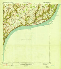
1948 Map of Owen
USGS Topo · Published 1948About this map
Rose Island Landing sits at the sharp bend of the Ohio River in Clark County, Indiana, marking a point of transition between the river's active shoreline and the dissected uplands. This late 1930s landscape is dotted with small rural nodes like Runyantown, Vesta, and the riverside settlement of Owen, each serving a community defined by its proximity to steep hollows and winding creeks. The survey captures a high density of rural institutions, including Salem Ch, Golden Valley Sch, and Beech Grove Sch, reflecting a social fabric organized around family farms and local parishes. To the south, the Indiana Military Reservation occupies a significant portion of the riverfront, while the topography is deeply carved by drainage systems like Fourteenmile Creek and Yankee Run Creek. The map provides an intricate view of the river's islands and bars, including Eighteenmile Island, essential for understanding pre-war river navigation and the local terrain of southern Indiana.
Find a feature on this map
29 named features on this map. Tap any name to fly to it.
Don’t see what you’re looking for? This feature index may not catch every label — zoom into the map to look around manually.
Map Details
Editions of this 1948 Owen Map
2 editions found
Other maps of this area

1905 · Prospect
USGS Topo · 1:62,500

1912 · Prospect
USGS Topo · 1:62,500

1932 · La Grange
USGS Topo · 1:62,500

1937 · Jeffersonville
USGS Topo · 1:24,000

1937 · Charlestown
USGS Topo · 1:24,000

1938 · Owen
USGS Topo · 1:24,000

1939 · Bethlehem
USGS Topo · 1:24,000

1946 · Jeffersonville
USGS Topo · 1:24,000

1948 · Bethlehem
USGS Topo · 1:24,000

1948 · Owen
USGS Topo · 1:24,000