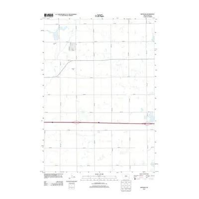
2012 Map of Spencer
USGS Topo · Published 2012About this map
Spencer serves as the primary settlement on this South Dakota prairie landscape, reflecting the grid-based development of McCook County in the early 21st century. The terrain is defined by its numerous small depressions and seasonal water bodies typical of the region, with Lake Eli standing out as a permanent geographic anchor to the northwest. The map documents the established section lines and agricultural road network, such as 252nd Street and 430th Avenue, which have organized the land since early settlement. This survey provides a precise look at the rural infrastructure and land use patterns, showing the relationship between the small town center and the surrounding glacial-till landscape.
Find a feature on this map
2 named features on this map. Tap any name to fly to it.
Don’t see what you’re looking for? This feature index may not catch every label — zoom into the map to look around manually.
Map Details
Editions of this 2012 Spencer Map
This is the sole edition of this map. No revisions or reprints were ever made.
Other maps of this area

1899 · Alexandria
USGS Topo · 1:125,000

1955 · Sioux Falls
USGS Topo · 1:250,000

1958 · Sioux Falls
USGS Topo · 1:250,000

1964 · Salem
USGS Topo · 1:24,000

1964 · Bridgewater East
USGS Topo · 1:24,000

1971 · Unityville
USGS Topo · 1:24,000

1973 · Spencer SW
USGS Topo · 1:24,000

1973 · Farmer
USGS Topo · 1:24,000
1973 · Bridgewater West
USGS Topo · 1:24,000

1973 · Canova SE
USGS Topo · 1:24,000