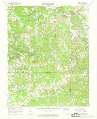
1967 Map of Spencer
USGS Topo · Published 1968About this map
North Mayo River and South Mayo River define the undulating landscape along the Virginia and North Carolina border during the late 1960s. This survey, published by the Commonwealth of Virginia and the USGS, documents a rural network of crossroads and small settlements like Spencer, Penns Store, and Trent Store. The map provides substantial detail for genealogists, marking family-connected landmarks such as the Harris Cem and Gibson Cem, alongside vital community hubs including the Spencer-Penn Sch and several country churches like Spoon Creek Ch and Red Hollow Ch.
Find a feature on this map
39 named features on this map. Tap any name to fly to it.
Don’t see what you’re looking for? This feature index may not catch every label — zoom into the map to look around manually.
Map Details
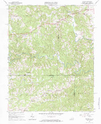
Editions of this 1967 Spencer Map
2 editions found
Other maps of this area

1924 · Martinsville
USGS Topo · 1:48,000

1926 · Martinsville
USGS Topo · 1:62,500

1926 · Critz
USGS Topo · 1:48,000

1927 · Martinsville
USGS Topo · 1:62,500

1928 · Critz
USGS Topo · 1:62,500

1944 · Martinsville
USGS Topo · 1:62,500

1953 · Winston-Salem
USGS Topo · 1:250,000

1953 · Greensboro
USGS Topo · 1:250,000

1954 · Greensboro
USGS Topo · 1:250,000

1955 · Winston-Salem
USGS Topo · 1:250,000