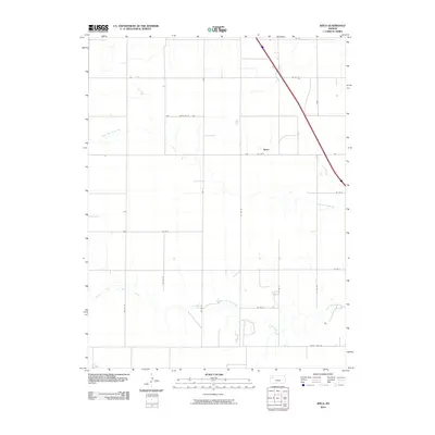
2010 Map of Spica
USGS Topo · Published 2010About this map
The Spica settlement area in Thomas County, Kansas, sits on a high, wind-swept plateau defined by the drainage basins of two major prairie waterways. The North Fork Saline River cuts across the northern half of the quadrangle, while the South Fork Saline River meanders through the southern reaches. This 2010 survey illustrates a landscape dominated by large-scale agricultural operations, where a strict section-line road network, including Co Rd 24 and Co Rd 25, provides access to the vast fields between the river forks. The layout of the roads and the sparse distribution of named points highlight the transition toward consolidated farming in western Kansas during the early 21st century. Along the southern boundary, County Line Rd marks the transition into neighboring territory, while the interstate highway slices diagonally through the northeastern corner, linking this rural agricultural heartland to the wider regional corridor.
Find a feature on this map
18 named features on this map. Tap any name to fly to it.
Don’t see what you’re looking for? This feature index may not catch every label — zoom into the map to look around manually.
Map Details
Editions of this 2010 Spica Map
This is the sole edition of this map. No revisions or reprints were ever made.
Other maps of this area

1943 · Colby
USGS Topo · 1:62,500

1954 · Goodland
USGS Topo · 1:250,000

1956 · Goodland
USGS Topo · 1:250,000

1957 · Goodland
USGS Topo · 1:250,000

1967 · Colby SE
USGS Topo · 1:24,000

1972 · Monument
USGS Topo · 1:24,000

1972 · Winona NE
USGS Topo · 1:24,000
1979 · Oakley SW
USGS Topo · 1:24,000
1979 · Oakley South
USGS Topo · 1:24,000
1979 · Mingo
USGS Topo · 1:24,000