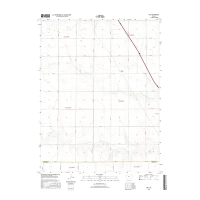
2015 Map of Spica
USGS Topo · Published 2015About this map
The High Plains of Thomas County meet the northern edge of Logan County in this 2015 survey of the area surrounding Spica. The landscape is defined by the subtle drainage patterns of the N Fork Saline River and the S Fork Saline River, which cut through the agricultural sections of the Kansas interior. The map reveals a strictly geometric grid of county roads, including Co Rd 412 and Co Rd 23, reflecting the systematic land partitioning of the region. This modern topographical record captures the sparse settlement patterns typical of the western Kansas plains, where the Thomas Co Logan Co boundary line divides large expanses of prairie and farmland. The presence of Kismet Dr in the southeastern corner suggests more recent local development amidst the established rural townships of t10s r32w and t11s r32w.
Find a feature on this map
28 named features on this map. Tap any name to fly to it.
Don’t see what you’re looking for? This feature index may not catch every label — zoom into the map to look around manually.
Map Details
Editions of this 2015 Spica Map
This is the sole edition of this map. No revisions or reprints were ever made.
Other maps of this area

1943 · Colby
USGS Topo · 1:62,500

1954 · Goodland
USGS Topo · 1:250,000

1956 · Goodland
USGS Topo · 1:250,000

1957 · Goodland
USGS Topo · 1:250,000

1967 · Colby SE
USGS Topo · 1:24,000

1972 · Monument
USGS Topo · 1:24,000

1972 · Winona NE
USGS Topo · 1:24,000
1979 · Oakley SW
USGS Topo · 1:24,000
1979 · Oakley South
USGS Topo · 1:24,000
1979 · Mingo
USGS Topo · 1:24,000