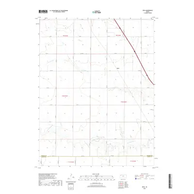
2018 Map of Spica
USGS Topo · Published 2018About this map
Spica sits at the center of this High Plains landscape, where the agricultural grid of Thomas County meets the drainage of the Saline River system. The terrain is defined by the winding paths of the N Fork Saline River and the S Fork Saline River, which cut across the otherwise orderly section lines. This 2018 survey shows a rural environment primarily organized by a network of county roads, such as Co RD 412 and Co RD G, which facilitate the region's farming and ranching operations. Along the southern boundary, the transition at the Thomas Co Logan Co line is marked by Fort Fox, providing a specific point of interest for those studying the local geography and historical land divisions of Western Kansas.
Find a feature on this map
30 named features on this map. Tap any name to fly to it.
Don’t see what you’re looking for? This feature index may not catch every label — zoom into the map to look around manually.
Map Details
Editions of this 2018 Spica Map
This is the sole edition of this map. No revisions or reprints were ever made.
Other maps of this area

1943 · Colby
USGS Topo · 1:62,500

1954 · Goodland
USGS Topo · 1:250,000

1956 · Goodland
USGS Topo · 1:250,000

1957 · Goodland
USGS Topo · 1:250,000

1967 · Colby SE
USGS Topo · 1:24,000

1972 · Monument
USGS Topo · 1:24,000

1972 · Winona NE
USGS Topo · 1:24,000
1979 · Oakley SW
USGS Topo · 1:24,000
1979 · Oakley South
USGS Topo · 1:24,000
1979 · Mingo
USGS Topo · 1:24,000