
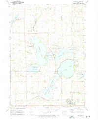
1970 Map of Spirit Lake SE
USGS Topo · Published 1972About this map
The resort and recreation landscape around Arnolds Park defines this 1970 Dickinson County survey, where the chain of lakes creates a distinct corridor of activity. To the west, Okoboji Lake, Upper Gar Lake, Minnewashta Lake, and Lower Gar Lake are bordered by an extensive network of conservation lands including the Spring Run State Game Management Area. This area illustrates the balance between seasonal tourism at the Campground and Golf Course and the preservation of the surrounding marshlands.
Find a feature on this map
27 named features on this map. Tap any name to fly to it.
Don’t see what you’re looking for? This feature index may not catch every label — zoom into the map to look around manually.
Map Details
Editions of this 1970 Spirit Lake SE Map
This is the sole edition of this map. No revisions or reprints were ever made.
Other maps of this area

1954 · Fairmont
USGS Topo · 1:250,000

1958 · Fairmont
USGS Topo · 1:250,000

1966 · Spencer
USGS Topo · 1:24,000

1966 · Dickens
USGS Topo · 1:24,000

1970 · Milford
USGS Topo · 1:24,000

1970 · Okoboji
USGS Topo · 1:24,000

1970 · Spirit Lake
USGS Topo · 1:24,000

1972 · Terril
USGS Topo · 1:24,000
1972 · Ruthven
USGS Topo · 1:24,000
1972 · Superior
USGS Topo · 1:24,000